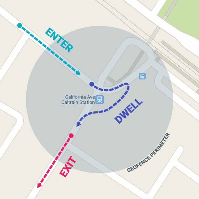
Geofencing combines awareness of the user's current location with awareness of the user's proximity to locations that may be of interest. To mark a location of interest, you specify its latitude and longitude in the CMS. To adjust the proximity for the location, you add a radius which must be at least 500 meters for accuracy’s sake. The latitude, longitude, and radius define a geofence, creating a circular area, or fence, around the location of interest. Lastly, it’s required to specify a date range to mark the duration of this geofence. When it expires, it will automatically be deleted from user’s devices.
Once a user enters a geofence, a notification will be sent. This notification can contain text and an optional image or link. You can also choose to send it to spectators, participants or volunteers only.
You can include sponsor messages, offers, awareness etc. It can be used on the course, near the course, or for expos.

1) Feature Specifications
- Geofences is only available for White-Label apps. It is not available for Sporthive Live Events.
- A maximum number of 10 geofences per event and per series is possible.
- Geofences for events in Series / TimerApps will be removed after 5 days, to be able to set up 10 geofences again for your next event.
- Geofences are linked to an event. It is not possible to set up Geofences for your Series / TimerApp.
- Maximum number of characters is 255. This includes spaces.
- For a SeriesApp or TimerApp, it's only possible to setup a Geofence per event and not for the whole app.
iOS
- Enable the feature in the Event Quick Start Wizard, before submission of your app. This is required, because it requires location permissions.
- The user must permit the app to have ‘always’ location access.
- A geofence only fires.
If a geofence is added after the app was submitted to the app store, it will only be registered by the app when:
- The user triggers a configuration refresh (happens automatically five seconds after the tiles view loads, so normal use of the app will trigger this).
OR
- The configuration gets automatically refreshed in the background. iOS decides how that happens. The app just says ‘hey iOS, I want you to check for new configuration updates, and I want you to do that as frequently as you want to’.
Geofence only fires after a certain amount of time in the geofenced area.
Android
- Android location points are rated for accuracy, by a 1 for inaccurate to 5 for very accurate. The geofencing check runs every so often, and ONLY triggers when the device can deliver an instant 5-point accuracy location point.
- Android bases location data on 3 things: GPS, Cell-ID, and Wi-Fi. Having all three enabled will dramatically increase the chance to get a 5* location point.
- A lot of other and even external factors will influence how fast an accurate location can be determined. Battery life, quality and location of GPS antenna, physical location (i.e. indoors or between lots of skyscrapers or trees).
2) Configuration in the CMS
1. Go to Config > Geofence.
2. Create a Geofence.
3. Fill in epi center of Geofence, or location you are promoting in space above map on right parameters.
- Can geofence to send messages to users of one (1) app in a SeriesApp.
- Can geofence to send messages to users of the SeriesApp (all events apply).
Radius of Geofence:
| MINIMUM | YARDS | FEET | MILES | KILOMETERS |
| 500 meters | 545 | 1640 | .3 | ,05 |
| 25.000 meters | 27,340 | 82,020 | 15 miles | 25 |
A maximum of 10 geofences per app allowed.